Guest blog – Walshaw Turbine 22 by Nick MacKinnon – Mark Avery

Nick MacKinnon is a freelance teacher of Maths, English and Medieval History, and lives above Haworth, in the last inhabited house before Top Withens = Wuthering Heights. In 1992 he founded the successful Campaign to Save Radio 4 Long Wave while in plaster following a rock-climbing accident on Skye. His poem ‘The metric system’ won the 2013 Forward Prize. His topical verse and satire appears in the Spectator, and his puzzles and problems in the Sunday Times and American Mathematical Monthly. Email: nipmackinnon@gmail.com
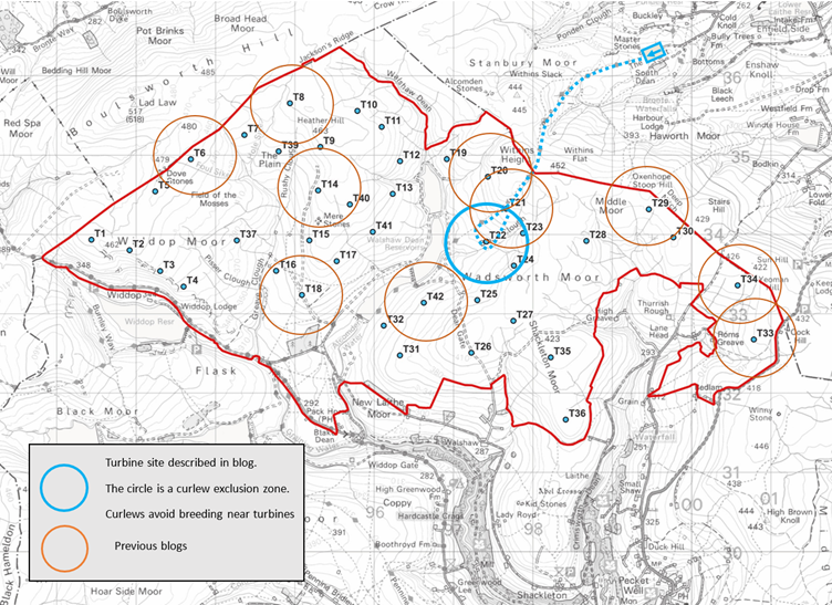
Turbine 22 Black Clough SD 97411 33914 ///stammer.lizards.league
Logika and CWF Ltd were sent this blog for comment on 13 October 2025. Since first being alerted to the possibility on 30 September 2025, neither Logika nor CWF Ltd have denied that their Scoping Report contains instances of prima facie A.I. hallucination. Neither Logika nor CWF Ltd have contested the statement, published here on 3 October 2025 with extensive evidence, that the CEP Scoping Report is incompetent.
9 October 2025 We return to the questions of access and aggregate. Like CEP itself, we must assemble our materials from distant places scattered all over the Logika Scoping Report.
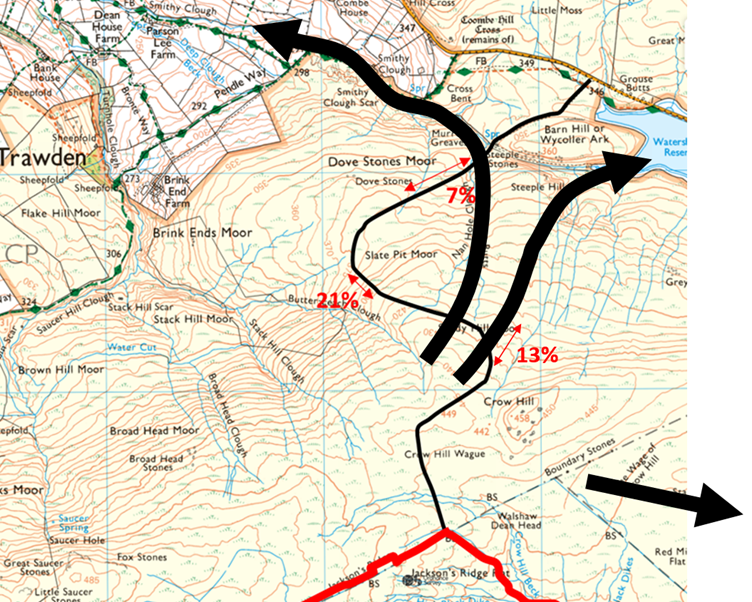
First a quick trip to T22, Christian ‘The Eagle’ Egal’s gift to the Walshaw satirist, because delivery experts Collett of Halifax, one of the most innovative firms in the UK, might as well send the blades down the 26% edge like toboggans…
As I was writing that sentence, the alert pinged and the Planning Inspectorate published their opinion on the SR and all the commentary they received. It is a battering for Logika and Calderdale Wind Farm Ltd. Success has many fathers, but failure is an orphan. The investor Dr Ghazi Osman may be wondering if he can get his £4 million back from Richard Bannister; the lawyers may be telling him that he can’t, so maybe it’s time to cancel before the 2026 million-quid instalment is due, and attaching their own reasonable invoices for services rendered. As ever, I encourage Dr Osman to sue Christopher Wilson and offer my services as an expert witness.
“Now Mr Wilson, can you explain to the court how Collett and Sons were meant to get an 80-metre turbine blade down to T22.”
“The site was purely indicative …”
“But where in the brochure does it say ‘indicative?’. How was Dr Osman meant to know what was real and what was ‘indicative’?”
“Well, obviously it’s indicative! As that chap Egal was saying, ‘Vous ne pouvez pas descendre une piste rouge sur un snowboard de quatre-vingts mètres!’”
Of course, Dr O and Kelvin-Volts may first club together to sue Logika, vulnerable after assembling the first-ever hilarious Scoping Report, some of which seems to have been written by Marvin, their in-house comedy robot. All the evidence and consultee commentary on Logika’s incompetent Scoping Report are now displayed on the Planning Inspectorate site. The Inspectors, acting on behalf of the Secretary of State, have said that the road numbers had better be right next time and point out that Logika will find Ali West’s remarkable list of corrections in Appendix 2; that all the Logika maps must display the latest layout; and no, they aren’t going to scope out Amplitude Modulation on the Logika Principal Consultant’s say so. The Stronger Together analysis, the work of two years, and an intensive 29 days, appears in toto.
The response most likely to get the investors checking their trouser pockets is the Environment Agency on the Flood Risk Assessment. Ouch! If you think these blogs are a bit hard on Logika and CWF Ltd, have a look at what the EA say on p 577. Many bodies commented on culture and heritage: ‘the unprecedented nature of the proposal in an important cultural landscape … the applicant is advised to approach the Brontë Society …’ If CWF Ltd are going to continue, they will have to explain to the investors why they sent the Secretary of State this unprofessional and incompetent Scoping Report and what they are going to do about it now, because it is not a foundation for an EIA. It is scorched earth.
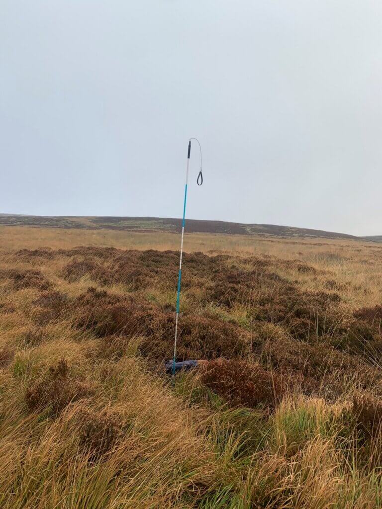
I like to reach the turbine sites the way the track would go, but Teddy the Airedale is at school, and I’m not sliding down the 1 in 4 edge without my furry belayer, so I cut in from the Pennine Way over an active bog with excellent moss hummocks, measure the T22 peat depth at 75 cm and head up the looming edge. Drizzle is blowing on a Force 5, but I strip down to a tee-shirt because it’s bloody steep.
A late developer, there is big trouble for CEP in its early twenties. T20 thinks it can’t be seen from Wuthering Heights; T21 is built directly above the Pennine Way like a crazy golf obstacle; T23 has its wind stolen by T24 and T22, which has toppled over the edge. There is wind in this area for one turbine, not five, and it would be T24. T19 then dies of gangrene and that’s 36 MW flushed down Black Clough before breakfast.
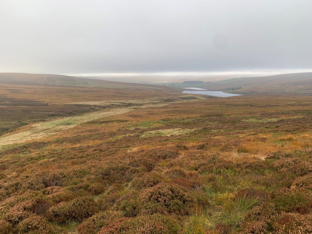
New readers looking at this photograph might think, “Why don’t they build a nice wind farm round the reservoirs and use the Yorkshire Water tracks for deliveries?” One answer based on Access is here, under “Widdop Road”. A second is that it would be too small at 101 MW installed (37 MW on average over a year) to carry conviction when the Secretary of State weighs the other factors, which include unravelling the Kunming-Montreal treaty, a triumph of British nature diplomacy, and destroying Brontë Country, the inspiration for three of the most famous women in the history of the world. A third is that it is that it would be too small to carry its connection costs.
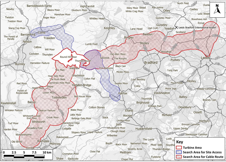
The Executive Chairman may still be uncertain about the voltage of the National Grid, but he has always known that the connection is a problem, and forces two sizes on the wind farm. Either he plugs 170 MW into the district network at Rochdale with a dig cost of £30 million; or sends 300 MW to the National Grid at Narnia substation “north of Leeds” for £60 million. Both prices are large (more than 10% of the budgets) compared to well-sited wind farms. The pink cable corridors in the Scoping Report map above show the problem, and I apologise for any offence caused in what has always been a family blog, broadcast either side of the watershed. Mr Wilson has got 440 Kelvin-Volts, but he doesn’t really have 300 MW, so his pink corridor is the Rochdale Detumescence rather than the Halifax Bomber. The absolute aerodynamic limit of Walshaw Moor, given concessions already made in the layout to the National Trust and Emily Brontë, is 230 MW. Does Dr Osman know that?
As well as Rochdale and Narnia, Elland and Bradford West substations have been mentioned by CWF Ltd. The Planning Inspectors wonder why there were no corridors for them on the map above. Bradford West happens to be in the Narnia corridor, but Elland is south of Halifax and has no pink extension. This map was made by the Logika A.I. hobbit Turbo Baggins, who uses the Shire hamlets Sawood and Lumb Foot to represent internationally renowned Haworth; no substations are shown but at least Bradford and Leeds appear along with Slippery Moss and Roger Moor.
True Grit
Now, let’s start to dig the aggregates out of the Scoping Report, starting with the borrow pits.
5.8.1 Borrow pits. The Proposed Development would require quarried stone to construct new tracks, hardstandings and compound areas, and where suitable to improve the existing tracks within the Turbine Area. The crushed stone will be required to form the track and hardstanding surface areas for the cranes and the site tracks. Suitable volumes of quarried stone will be sourced from onsite borrow pits, where it is possible. The utilisation of onsite borrow pits will assist with minimising the potential environmental and transport network effects associated with transporting imported aggregate to the Turbine Area.
The Scoping Report has hundreds of references, many dumped in a block from Scotland, as the Planning Inspectors observe, but no mention is made of the annual West Yorkshire Aggregate Assessments 2012-2025, despite my sending the latest edition to the investor Dr Osman as a New Year peace offering. He’s got a right to know these things about Walshaw Moor.
The geological fundamentals have been known to CWF Ltd since I told them in April 2024, and Robbie Moore MP told them again in October 2024, on House of Commons stationery. The facts were finally acknowledged in a response to a question that I asked on the Webinar (21 May 2025, 43:40-45:27) during the Non-statutory Consultation. CWF Ltd rock star consultant Donald Mackay said, “The naturally occurring materials on the site are not the best quality for construction” and “A hardstone will have to be imported to strengthen the tracks.” The same point is made repeatedly in the annual West Yorkshire Aggregate Assessments by the five district councils.
“The sandstones are too weak and porous for the manufacture of concrete or for road building and are commonly used in low specification situations and for bulk fill.”
On the notes to the British Geological Survey sheet 77 Huddersfield, the freeze-thaw problem is stated.
“In general, the sandstones are too weak, porous and susceptible to frost damage for them to be used for good quality roadstone or concrete aggregate. They may be used in road construction below the level of possible frost damage and for some of the less demanding concrete applications.”
At his Trawden live gig I asked Donald Mackay about this point. “The gritstone won’t give you a roadstone, will it?”
“No, it won’t, and there is nobody round here who will sell you it for that purpose either! We call it bulk fill.” (It is this kind of frankness that makes Donald ‘Transparent’ Mackay a National Treasure. He has always told the truth about CEP, and he will always be in demand as a consultant.)
“How much bulk fill could be used in a metre-deep cut track through peat?”
“You get down to the boulder clay and measure the CBR (California Bearing Ratio). You put down a geogrid and then bulk fill then another geogrid. The top 40 cm of the track must be a hardstone.”
I asked about bulk fill on floating tracks.
“You want a floating track to be as light as possible, so only hardstone.”
We are at a crux for the proposal and its investors.
There are megatons of chemically suitable bulk fill available in West Yorkshire and Lancashire as waste from the quarrying of high-quality building stone. On Walshaw Moor there are no onsite edges that can be quarried horizontally, so any borrow pit would be a delph, in which a large flat area is cleared of peat and boulder clay to reach the stone, which is blasted, and raised vertically out of the hole before onsite crushing and grading. Walshaw Moor is an internationally designated Special Area of Conservation and governed by the Kunming-Montreal protocol, one of the proudest achievements of British nature diplomacy. Natural England should not permit CWF Ltd to open huge pits that can only supply a quarry waste that is cheaply available offsite. If Natural England allow borrow pits, then there is no limit to their servility, and further analysis would be otiose. A letter I had last week from Natural England reassures me they will fight hard for nature on Walshaw Moor. As soon as they are sure the proposal is so hopeless and incompetent that political support is draining away as local Labour MPs read the PI Scoping Opinion aghast, catch up with government policy in the report Unlocking benefits and work out what side of the fence they need to be on, Natural England can let rip. England will not make the tragic Scottish errors on peat lands.
Every gram of aggregate would be imported to the site. What kind of aggregate will it be?
When I asked Donald Mackay about the imported hardstone, I observed that he would not be allowed to use limestone because it was a blanket bog poison, and that the Estate complies perfectly in this matter by using “blue granite”. Donald Mackay was stricken by this news, and said limestone might be permitted for his tracks. I thought this the only thing I have heard him say that is definitely wrong. There is a limestone assumption in the Scoping Report too.
12.4.2 A56 between Colne and Skipton (to account for bulk material deliveries in the Yorkshire Dales).
This may be referring to aggregate for concrete, for which limestone might be permitted. Concrete is always highly alkaline whatever aggregate is used. There must be a membrane between the turbine foundations and the acid bog to protect the concrete from the bog and the bog from the concrete. The developers assume they can leave the concrete and steel rebar when the wind farm dies, but Natural England should insist that it is carefully removed. When the membrane fails, bicarbonate will leach into the blanket bog and kill the sphagnum. Worse, a reaction between rebar and acid bog would make ferrous sulphate, sold as a moss killer in every garden centre. Natural England won’t allow slow-release bog bombs in irreplaceable habitat, but it is too late in the Scottish peat tragedy, where the developers can walk away from decaying concrete stumps and the British taxpayer will have to extract them from the Flow Country like wisdom teeth.
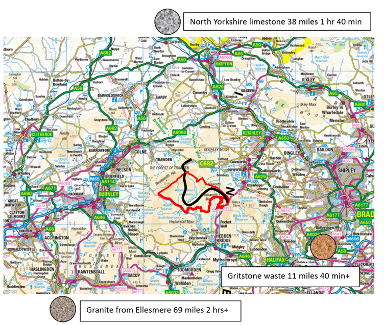
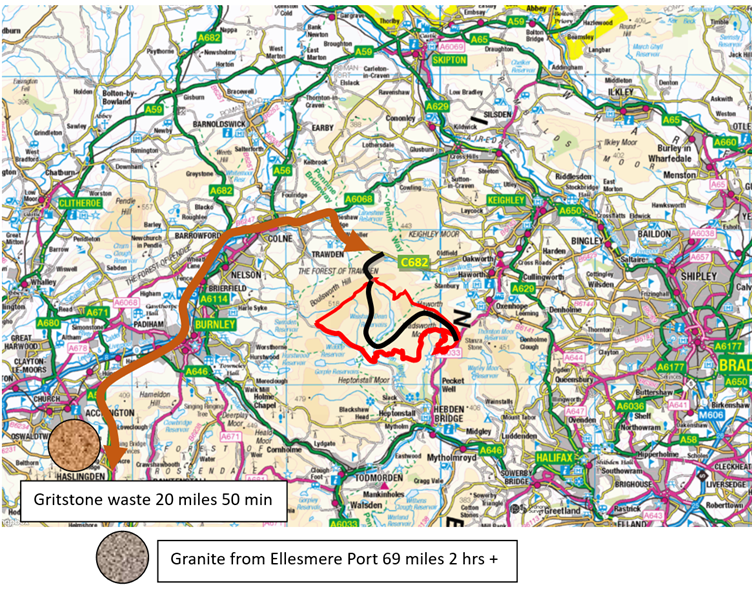
Donald Mackay must find an inert stone to strengthen his weak and frost-prone quarry waste. Glen Sanda on Loch Linnhe is a remarkable and innovative operation, blasting the Strontian pluton and sending granite downhill to a deep-water quay and all over Europe. Strontian (population 350) is a magnet for periodic table groupies. Bone-seeking strontium-90 was generated by our hydrogen bomb on Christmas Island and blown into our school milk, but the natural element is benign. After a restful cruise, Mackay’s granite would be unloaded at Ellesmere and jolted 69 miles up the Scoping Report’s “A56 corridor”. The transfers are always the worst bit of a package holiday.
12.4.2 A56 from Huncoat to the M56 (to account for bulk material deliveries on the A56 corridor)
The big Scottish and Welsh wind farms are built from strong onsite rock once the first borrow pit is reached. Given the present size of the proposal and that all the aggregates will be imported, CEP will involve the greatest movement of rock across country of any wind farm ever considered in the UK.
The stone quarries that will supply the chemically suitable gritstone waste are on the Hebble fault that runs from Ogden to Salterhebble. The gritstone will disintegrate to sand under freeze-thaw and should only be used in the deep sub-base below the freezing level, which means deeper granite. The Scoping Report has bulk deliveries of an unspecified nature coming up the M56 and this can only be the “No limestone please; we’re Natural England” granite.
The aggregate sources are clear enough now. The next problem is that trackless Walshaw Moor is in the way as granite and waste converge in a pincer movement on Colne and Hebden Bridge.
The key point now is that the C682 is not wide enough to allow two-way working by stone delivery HGVs.
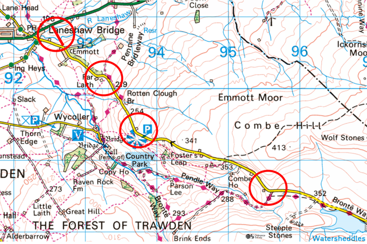
All the Statutory Consultees remark on the vagueness of the Scoping Report, but it does specify the blade delivery route, which will be via Colne, the C682, and a track over Crow Hill.
12.3.1 Construction access to the Turbine Area is proposed to be taken from the west and east of the site.
12.3.2 Currently, access to the west will also provide access for general construction traffic as well as Abnormal Indivisible Load (AIL) traffic associated with the delivery of wind turbine components. Access will be via the M65 and A6068 through to Laneshaw Bridge.
12.3.3 Currently, temporary access to the east will be taken for general construction traffic and construction staff from the A6033. [This is Cock Hill Swamp by ‘the elephant’.]
Realigning the C682 for blade deliveries is much easier than making it suitable for 45,000 deliveries of stone and 45,000 empty returns. The delivery rate, if spread over a specified working year, would be 180 loads per day, and the convoys couldn’t pass an on-coming ice-cream van. For two-way HGV working, HUAC specify a 6.75 metre road width which allows two 3-metre-wide lorries to pass, what highway engineers call “a bus route”. The turbine delivery only needs a 4.5-5 metre width, with some re-alignments that allow the 80-metre blades to be wiggled, which might only be a temporary intrusion into a farmyard. The delivery of turbine components is a picnic compared to the stone. The upgrade to bus route would be to permanent highway standards and the Scoping Report isn’t going to do that. It’s only going to wangle the pinch points for the blades in “discrete sections”.
12.4.12 The C682 is a two lane C class road operated by LCC. The road is sinuous in section as it climbs from the A6068 up towards the Proposed Development. The existing geometry of the road will require alterations in discrete sections to enable access by abnormal indivisible load traffic and these will be fully detailed in a Route Survey Report, that will be appended to the Development Consent Order (DCO) application documents.
We have got somewhere.
The Scoping Report proposes to make about four upgrades to the C682 that will allow delivery of 80-metre turbine blades, but it does not intend the improvement of the C682 that will allow it to be a feasible stone delivery route.
The turbine components don’t have to pass each other on the C682. They go in an overnight convoy through the silent streets of Colne and drop at a particular turbine site. They can wait until the following night to return.
All the stone would go east to Cock Hill Swamp, and the spine track would be built from there.
12.4.15 The A6033 from connections between Keighley in the north and Hebden Bridge to the south. The road is a two-lane local distributor standard road. The road is sinuous in nature in sections and peak period construction traffic may have a significant impact on the road users, depending upon the traffic levels that use the road.
12.4.16 The A464 provides an east-west connection between Lancashire and West Yorkshire, connecting Burnley to Halifax. The road is a two-lane local distributor standard road and is subject to 30mph speed limits within urban areas. The road is likely to be used by construction traffic for access and whilst the impact is unlikely to be significant, it has been included at this stage as it provides connections onto the A6033.
As we said last time, this paragraph must have been written by the rogue A.I. we call Marvin, though Logika have still given no account of their use of A.I. Marvin means the A646, not the A464 near Telford, and we humans know that it provides a west-east connection between Lancashire and West Yorkshire. The errors, and the downplaying language, suggests that the A646 is included just-in-case, when it is in fact fundamental and must carry all the stone. The Scoping Report is getting its aggregate deliveries in a twist, because Marvin is expecting limestone from the north for the tracks, just like Donald Mackay did at Trawden. Granite is not really factored into the plan and should be a deal breaker. It will certainly play havoc on the A646. Similarly, 12.4.17 below is about limestone deliveries from the north, but the roadstone will be coming from the south.
12.4.17 The A629 provides connection from Keighley in the north to Halifax. The road passes through several villages in the Worth Valley and is subject to tourist traffic visiting the Keighley & Worth Valley Railway and the Brontë sisters’ attractions in the area. Construction traffic flows may include bulk material deliveries and as such, may result in significant impacts.
The A6033 up from Hebden Bridge is a bus route but care is taken with the schedule so that two buses (they never reverse) do not meet on the steep uphill section between Hebden Bridge and through Pecket Well, where two cars cannot safely pass in places. For the convoys of stone there would have to be a one-way system with a lorry every three minutes which must never meet the descending bus.
This is a diabolical outcome for Hebden Bridge and the communities on the A646 (who would get the empty returns too, so a rate of one lorry every 90 seconds. The locals must always suck up a certain amount of disruption from an NSIP, but these aggregate deliveries are absurd, and they are caused by weak stone on a poorly selected site. Nobody read the aggregate assessments or BGS Huddersfield sheet 77 before starting the million-quid direct debits to Richard Bannister. Lead Consultant Alison Sidgwick told me at Oxenhope on 17 May 2025 that there was no requirement to look at a geological map yet. Two days later, Dr Osman stopped being a Person of Significant Control. Two days after that Donald Mackay finally admitted that the rock was weak. Why must the people of Calderdale and the Worth Valley pay for that failure to do the due diligence?
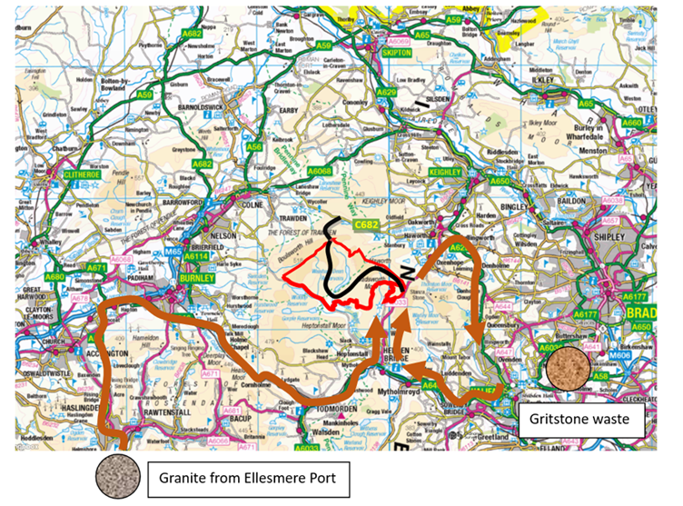
This solution is so terrible that we must consider alternatives. The only way out is to upgrade the whole of the C682 to allow two-way HGV traffic. Now the quarry waste could come from Huncoat at the top of the A56 corridor and the route would be a simpler two-way trip using the quiet motorway to Colne.
The problem for the landowner in this least-terrible scenario is that the stone lorries all go through his fiefdom. The C682 linking Boundary Mill to his grouse butts in Nan Hole Clough is to Richard Bannister what the road from Barad-Dûr to the Cracks of Doom was to the lidless eye of Sauron. A Wilson-Bannister contract must have been signed covering the new access route over Crow Hill. What did it say about the C682?
The spine track is then built backwards from Crow Hill to the A6033, though CWF Ltd won’t want to do that because the construction compound on Jackson’s Ridge will be a hellscape compared to cosy Cock Hill Swamp.
We made, and justified, two assumptions to get here: no limestone or borrow pits on the internationally designated SAC. We have corrected fifteen Logika road numbering errors to get to the truth. The proposal is in big trouble, and the investors are eyeing their chips and weighing their reputations. “You’ve got to know when to hold ’em; know when to fold ’em; know when to walk away; and know when to run. You never count your money when you’re sittin’ at the table; they’ll be time enough for countin’ when the dealin’s done”.
Blades over Crow Hill
We have shown that the 80-metre blades travelling horizontally cannot pass Halifax without an unusual amount of preparatory destruction, felling mature street trees and demolishing a building. The Cold Edge corniche beyond Halifax is then much more difficult to widen and realign than the C682. It would be possible to make less mess transiting Halifax and the corniche by using raised blade technology. We know the delivery of just 33 raised 60-metre blades caused chaos in Hawick; they were delivered by Collett & Sons of Halifax, who were in an excellent position to shake their heads if asked about 123 raised 80-metre blades through Halifax and along windy Cold Edge. We assume this is why Option A for the turbine components (still being sold to the public as late as 10 June 2025) has been silently deleted in the Scoping Report even though Option B has such a high risk of peat slide.
The fate of the proposal now lies in the access for the vast turbine components, including the 80-metre blades, from the west over Crow Hill, whose geology is famously prone to peat bursts (1824) and slides (1989) neither caused by putting a huge weight of stone down and driving enormous loads over it; they happened spontaneously during heavy rain after a drought.
The Scoping Report has 61 words to say about this existential issue.
8.3.26 To the north and outside of the Turbine Area, there are two recorded peat landslides, one of which is known as the Crow Hill bog burst (Ross, 2020), described by the Rev. Patrick Brontë. LiDAR data indicates no equivalent features within the proposed turbine area.
Note the tendency of this statement to minimise the significance of the Crow Hill bog burst for the proposal. Although the 1824 Crow Hill catastrophe on 2 September 1824 indeed started slightly outside the Turbine Area, all the turbine components will be delivered across Crow Hill. Ross 2020, though excellent, is primarily a post-doctoral literary thesis, and together with the instancing of the Rev. Patrick Brontë, who was not a soil engineer, but the father of three of the most famous women in the history of the world, 8.3.26 suggests that the 1824 bog burst was a remote, academic, or even gothic event. It was so extreme that the Aire was polluted at Leeds, and the reservoir pumps had to be turned off. A peat stain could be seen on the Humber.
The only other statement about soil mechanics on Crow Hill is the second sentence of this bit of A.I. slop composed by Marvin, the Logika house robot.
8.3.29 A large proportion of the Cable Corridor Search Areas and eastern Site Access Search Areas have no superficial deposits and where present, lie within peat deposits. The western Site Access Search Area is underlain by superficial deposits of Glacial Till where present.
Ross, 2020 is a remarkable book by Shawna Ross, Charlotte Brontë at the Anthropocene, which uses the 1824 catastrophe to explore the Brontë family’s writing about the environment. On page 78, Patrick writes about the peat burst that almost killed Emily and Anne.
“All nature sinks and dies beneath the sway/ Of those black waves that ponderous force their way.”
Ross continues, “His biodiverse litanies dwell on the intimate relations between human and non-human to condemn the disruption of Crow Hill’s fragile equilibrium by the human actions that unleash God’s wrath upon it as collateral damage.”
On page 87 Ross concludes: “Certainly, moor time is tectonic time, but the Crow Hill bog burst showed the Brontës that it is a paradoxical sort of time, both long and short. Not all geological changes occur over deep time.”
Fascinating though the Ross thesis is, CWF Ltd should be paying as much attention to the 1989 peat slide on Crow Hill, which we describe here because Logika couldn’t be bothered. Dykes and Warburton (Mass movements in peat (2006)) give a photograph of the remnants of the 1989 slide taken in 2005. The extent was 3.6 ha, and 46000 m3. The peat was originally 2-3 metres deep and 0.3-0.5 metres of depth remains. The terrain is not steep and corresponds to the ground crossed by the Crow Hill access road at 440 metres just before the last bend. A prolonged drought had affected England from November 1988, punctuated by short-lived but often abrupt phases of wet weather. On 19 May 1989, a record 2-hour point rainfall of 193 mm was recorded at Walshaw Dean Lodge (John Getty’s house in the middle of the turbine area). This is the record daily rainfall for May, and the most intense 2-hour rainfall recorded in Britain, known as the “Halifax Storm”.
The reference on peat slides in the Scoping Report gives a mildly daunting formula for the safety factor.
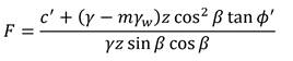
The numerator is the shear strength, the sum of the resisting forces, and the denominator is the shear stress, the sum of the destabilizing forces. The values of c′ (effective cohesiveness) and ϕ′ (angle of friction) can only be measured in situ and will depend on how fibrous the peat is and on the saturation m. If F is less than 1, a spontaneous peat slide is likely. The formula does not include the weight of the track and vehicles, nor the sideways reaction of a cornering vehicle. The model is an infinite slope of constant gradient, so the convexity on Crow Hill is not included either.
The variables in the denominator (shear stress) are available to us, because z is the peat depth, β is the slope angle and γ is the density of the saturated peat. I measured the peat depths along the Crow Hill track on the first legal day, 1 August 2025, finding 240 cm at the end of the west-east traverse below Crow Hill, the critical point on the corner where the sideways reaction forces from the cornering lorries and trailers are also at their most dangerous.
We can compare the relative shear stress at different places on the CEP infrastructure by assuming that the density γ is constant. For much of the spine track the figure is 0.00-0.01 because the track is flat on the wide watershed and there is no crossfall. On the descent to the bridge the track is steep but there is not much peat, and the figure is 0.04. There will be places inside the turbine area where we can find a higher figure, but only by deliberately putting a turbine in a foolish place. The worst turbine of all is today’s T22 where 70 cm deep peat and a 26% slope give a value of 0.17. This is an easy peat slide risk to eliminate: T22 gets taken out on the grounds that delivery tracks should have a maximum gradient of about 10% (there is one spur on Scout Moor at 15%) not 26%. Egal’s Folly should not be in Black Clough in the first place.
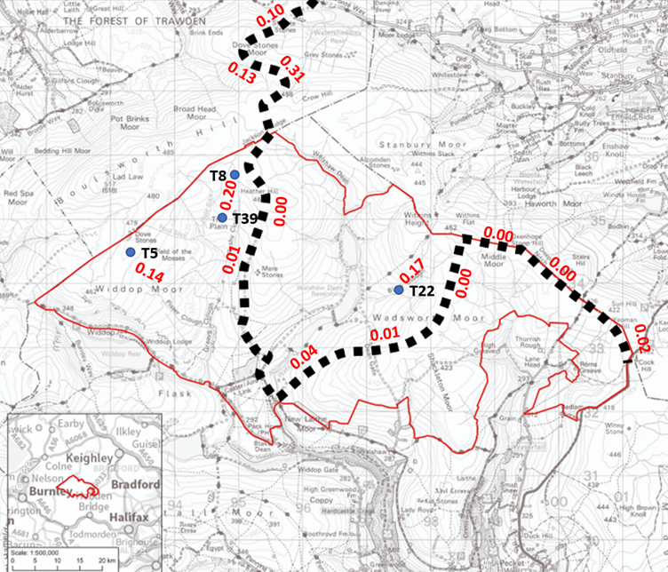
The usual way of avoiding all this is never to traverse one-metre-deep peat if the crossfall is more than 5%, equivalent to our relative shear stress figure of 0.05. Inside the turbine area, peat slides can be designed out by keeping the turbines near the spine track. West of Greave Clough is asking for trouble, but this area will surely be prohibited by Natural England on habitat grounds and then by the Environment Agency on flooding. The visual grounds on the charismatic Scout Ridge will mop up: it is Burnley’s Matterhorn. Otherwise, the maximum value of the shear stress figure on the Greave Clough infrastructure would be 0.14 and in peat slide territory. I remember Donald Mackay’s quiet “No! We don’t do that!” on a single outbreath when I ran my finger in a traverse across this slope from T37 to T39 via the deleted T38.
The track over Crow Hill gives much higher values of stress. Over Dove Stones Moor the slope is 7% and the peat is up to 1.5 metres deep giving 0.10. At the steep ascent parallel to Butter Leach Clough the peat is only 0.5 metres deep, but the gradient is 22% giving 0.13. But the worst place of all is on the traverse over the Nan Hole Clough drainage funnel, where the crossfall is 13%, the peat is 2.4 metres deep and the relative shear stress is 0.31. This figure is on terrain where peat slides have already happened, on a convex traverse, where the heavy turbine components must come across in a slow convoy and the sideways forces on the bend are greatest.
Every winter mountaineer dreads traversing deep snow on a convex slope in an area known for avalanches. You are taught to dig a 1.5-metre-deep snow pit to assess layer cohesion and lubrication, taking care not to trigger the avalanche by digging the pit. Then you go back the way you came.
The key reference to wind farm peat slides is Wind Farms and Blanket Peat: the Bog Slide of 16 October 2003 at Derrybrien, Co. Galway, Ireland by Richard Lindsay and Olivia Bragg. The comparison with Crow Hill is striking, as is the behaviour of the developers. The authors describe the Environmental Impact Assessment for Derrybrien as “salami slicing”, a vivid image that applies to the CEP Scoping Report as well. The developers slice up the risk, so the regulators lose sight of the sausage.
After Derrybrien, under no circumstances would a consultant as experienced and transparent as Donald Mackay even consider the Crow Hill track were it a turbine site spur like the one to T22. He would simply move the turbine, but on Crow Hill he must move the whole wind farm, and to use his own expression when I asked him about the opaque ownership of CWF Ltd, “That’s above my pay grade.”
I am sorry the Crow Hill map has Donald’s name on it as Approver. He is an outstanding consultant and will survive this brush with an incompetent company. He acted in the same rush as Christian Egal, who arrived in February and by the end of April had launched what WTRG call an unlawful Non-statutory Consultation with seven incorrect maps and a dud layout, and as Logika, who failed to check the work of Marvin and whose Scoping Report has been shredded in public. CWF Ltd might have raised more capital on the back of a competent Scoping Report, but the money hates being laughed at, and it can get 5.56% in risk-free 30-year Government debt, our grandchildren’s burden, which we seem unable to control, so we have to beg for foreign investment in our electricity generation. If we want the money, we must give the money proper sites for onshore wind rather than internationally designated peat lands on weak geology, and our local management must in future be far more competent than CWF Ltd and Logika.
It is in the self-interest of actors under contract to keep a dud show on the road. With a dud site there is an inevitable misalignment of incentives between the investors in Calderdale Energy Park who want to know now about the peat slide risk, and their consultants who don’t. Logika published 61 words on the matter: 45 words were a review of a book none of the consultants are likely to have have read yet, and 16 were A.I. slop by Marvin.
The money now has to reckon that an unresolved peat slide risk must be financed indefinitely, and it a very serious risk, with the potential for the stranding of the proposal, multiple deaths, and prosecutions for corporate manslaughter, because Crow Hill is the only way to get the turbine blades onto Walshaw Moor.
++++++++++++++++++++++++++++++++++++++++++++++++
This is the 46th in a series of guest blogs originally based on the 65 wind turbines which Richard Bannister planned to have erected on Walshaw Moor. Turbines 5, 6, 6CEP, 8, 8CEP, 9, 11, 13, 14CEP, 14, 16, 17, 18CEP, 20CEP, 21, 21CEP, 25, 25CEP, 27, 29CEP, 31, 32, 33, 33CEP, 34, 34CEP, 35, 36, 37, 38, 40, 42, 42CEP, 43, 44, 47, 53, 54, 56, 57, 58, 60, 62, 64 and 65 have already been described.
The developers have canned their original 65 wind turbines, quite possibly in response to the public humiliation of having their so-called ‘plan’ publicly shown to be damaging, irrational and probably unlawful. They have come back with a plan for 42 wind turbines and the amazing Nick MacKinnon and friends have regrouped and set off on a new tack too. The series continues.
To see all the blogs – click here.
[registration_form]


